Geographically, Glacier National Park is a part of the Rocky Mountain Front which is often referred to the “Crown of the Continent,” an area over 100 miles from the central regions of Montana to southern Alberta of Canada. This is where the Rocky Mountains meet the Great Plains in an abrupt altitude rise of between 4,000 to 5,000 feet. North of Rocky Mountain Front is the Canadian Rockies that includes four popular Canadian National Parks: Banff and Jasper on the eastern side and Kootenay and Yoho on the western side. To the Southeast of it, famed Yellowstone National Park is about 250 miles away, mostly in the state of Wyoming.
We recently visited Rocky Mountain Front. The journey started from Florence, a small town 20 miles south of Missoula, Montana where a long time friend lives. Traveling north in Bitterroot Valley along the Bitterroot River, the scenery changes when one enters the Mission Valley with southern Mission mountains at the east. Through Flathead Reservation and around the Flathead Lake, one reaches
 the west entrance of Glacier National Park few hours later after seeing some vast golden rape flower fields (photo to the right) where Canola oil comes from. Flathead Lake itself (see photo below), approximately 30 miles long and 16 miles wide, is the largest natural clear water west of Mississippi in U.S. and a popular destination for many vacationers as well.
For those who enjoy sightseeing with the comfort of four wheels instead of with two legs, the memorable 50 miles long winding Going-to-the-Sun Road is second to none. It cuts through the Glacier National Park from its west to its east entrance that get you front seat views of some of its glaciers, large lakes, and impressive peaks and valleys.  With its high latitude and elevation, portion of the road is closed between mid Sept and mid June that makes it most practical to visit the Park in the summer. At a little over half way point shortly after the Weeping Wall (yes, this wall off the roadside does weep; see photo to the right), one can take a break at the Logan Pass, approximately 7,000 ft above the sea level. One can enjoy a breadth-taking 360 degree view of surrounding mountain ranges
  and peaks of the Rockies. Occasionally, deers and mountain goats may pass you by while mulching on flowers and grass, ignoring your mere-human existence. You can also hike a little towards to the Hidden Lake below Mount Clement to stretch your legs (photo to the right).
 With its high latitude and elevation, portion of the road is closed between mid Sept and mid June that makes it most practical to visit the Park in the summer. At a little over half way point shortly after the Weeping Wall (yes, this wall off the roadside does weep; see photo to the right), one can take a break at the Logan Pass, approximately 7,000 ft above the sea level. One can enjoy a breadth-taking 360 degree view of surrounding mountain ranges
  and peaks of the Rockies. Occasionally, deers and mountain goats may pass you by while mulching on flowers and grass, ignoring your mere-human existence. You can also hike a little towards to the Hidden Lake below Mount Clement to stretch your legs (photo to the right).
 As one continues east towards to the east entrance of the park at St. Mary, Triple Divide Peak gets closer at times where fresh water flows down three ways to: Pacific Ocean at west through Columbia river, the Gulf of Mexico at south through Missouri River and then Mississippi River, and Hudson Bay at north which is connected to Atlantic Ocean and Arctic Ocean.
 We stayed at the Many Glacier Hotel (see photo to the right; early reservation is essential to get a room here) which is one of the major bases at north-eastern part of the Park. A rustic hotel almost 100 years old built on the shores of Swiftcurrent Lake, one of over 700 lakes of the park, at the base of Mount Grinnell. One can sit all day long on its deck soak in the sun and the lake
  with reflections of mountains including Mt. Wilbur at the west and Mt. Gould at the Southwest. Occasionally, you may see a deer or a moose wondering around in the water few thousand feet away across the lake (photo at right)
 There are over 700 miles of trails in the Park. One of the most rewarding hikes is an approximately 10 miles round-trip trekking with 1200 ft climb from the trailhead behind the nearby Swiftcurrent Motor Inn to the Iceberg Lake. Next to the trail, Beargrass (no, bears don't eat them), blossom wild flowers, and ripping berries of mid July welcome hikers before Grizzly bears descend for a feast of them.
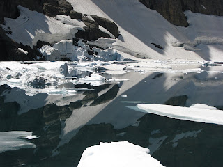
At the end of the trail, Iceberg Lake, carved by glacier a long long time ago sleeps alone with its brilliant turquoise icy water and floating icebergs as the name promised. Under the protection of Iceberg Peak and flanked by the Ptarmigan Wall, one can have a leisure picnic while enjoying this rare and surreal scenery (see three photos below). If you are lucky like us, you may see some mountain goats came down the steep slope at a distance .
. 
 Talking about glaciers, the bad news is with accelerated global warming, glaciers are retreating faster than ever. Current prediction forecasts that by 2020, all the remaining 27 glaciers will be gone from the park. Can you imagine how Glacier National Park would look like when that happens? Like a mountain goat without any hair?
 .
. 
 Talking about glaciers, the bad news is with accelerated global warming, glaciers are retreating faster than ever. Current prediction forecasts that by 2020, all the remaining 27 glaciers will be gone from the park. Can you imagine how Glacier National Park would look like when that happens? Like a mountain goat without any hair?
  Going north before crossing the U.S. Canada border at the Chief Mountain Customs and entering Canada’s Waterton Lakes National Park, one gets views of the most well-known landmark of Glacial National Park – the sacred Chief Mountain (see photo at right). Its dramatic rise of more than 1,000 ft is clearly visible from far away. Its rectangular hat-like shape cannot be more different and reminds me of the famous Matterhorn of the Swiss Alps that has a pyramidal shape.
  One way to enjoy the Waterton Lakes National Park is to take a 2.5 hours lake cruise of the upper Waterton Lake (photo at right) with a stop at the Goat Haunt Ranger station. The cruise takes you through one of the narrowest place of the Rocky Mountains with gusty wind easily over 20 miles/hour in a typical day. Few bald eagles fly from one tree top to another on the lake shores just to tease the tourists . In the south, Mount Cleveland stood proudly at 10,466 ft above the sea level, the highest peak of Glacier National Park.
  Short drives from the historical Prince of Wales Hotel overlooking the lake take you to Bison Paddocks, north of the park, where you can see Bisons roaming on prairie and beautiful Mountain Bluebirds parking on the fence (photo at left).
  If you go west from the hotel on Akamina Parkway, in 10 miles, you reach the end of the parkway and come to the scenic Cameron Lake at the foothill of Mount Custer (see photo to the right).
 Of course, Mount Custer is named after George Armstrong Custer, the young, ambitious and controversial lieutenant colonel of U.S. Army who led his 7th Cavalry Regiment to death in the Battle of Little Big Horn (in today’s south-eastern Montana) in 1876, defeated by allied forces of Lakota Sioux, Northern Cheyenne, and a small band of Arapaho warriors commanded by Lakota Sioux Chief Sitting Bull. Custer and all of over 200 of his men with him were killed in the battle, one of the worst disasters in American military history. Incidentally, the battle of Little Bighorn was the last victory of the American Indians against U.S. With the humiliating loss, U.S. government sent in more troops that overwhelmed the American Indians, drove them onto the Reservations and destroyed their spirit. Decades of American Indian Wars ended with Wounded Knee Massacre (in South Darkota) on December 29, 1890 when over 300 American Indian men, women and children of the last resisting Lakota group were killed.
Leading to that fateful day of 1876, Treaty of Fort Laramie (or Sioux Treaty) was signed in 1968 between U.S. government and Lakota people that included guarantee for Lakota's ownership of the Black Hills, a sacred area of Lakota people. Custer knowingly violated the treaty and entered the area with his expedition in 1874 that brought the Black Hills Gold Rush. Many skirmishes and two years later, Custer met his fate and died at the Battle of Little Bighorn.
Tracing back in history, the inevitable conflicts with native American Indians began in early 19th century when Americans started its westward expansion, championed by the 3rd President Thomas Jefferson. In 1803, U.S. completed the Louisiana Purchase deal with France that includes areas all the way to the headwaters of Missouri River. President Thomas Jefferson subsequently obtained funds from Congress and named Captain Meriwether Lewis to lead an expedition to: find out and map exactly what the purchase entails territory wise, if there are waterways (for easy transportation) to Pacific coast, and to study the habitats and establish contacts with the Native Americans of the area. That is the famous and successful Lewis and Clark Expedition of 1803-1806.
With the challenge of the Rocky Mountains, the Expedition had spent most of its time in today’s Montana struggling to find their ways. Fortunately, Sacagawea, an Shoshone woman, agreed to be a guide and interpreter for the expedition and helped them out. She and her family accompanied the Expedition for the rest of their journey and was instrumental to the success. Who among the native American Indians including Sacagamea would have thought the friendship was returned decades later with invasions, forced assimilation, and cultural genocides?
Technically, native American Indians have some level of sovereignty or independence from the government of the United States since the very beginning, thus the autonomous "Indian Nations". But with the consistent assimilation (voluntary, induced, and forced included) policy of the U.S. government, the expectation and eventual outcome cannot be mistaken.
In 1829, President Andrew Jackson proposed in his State of Union address to drive American Indians to west of Mississippi River. A year later in 1830 American Congress passed the Indian Removal Act. In 1851, the Congress passed the Indian Appropriations Act that places American Indians on reservations. With all these and with wars and treaties after treaties between the United States and various Indian Nations, nothing could stop the erosion of scattered native American Indians' standings when faced with a much larger and stronger power. Today, there are 562 officially recognized (by Federal Government) American Indian and Alaskan tribes, totaled near 2 millions. The estimates for the population of native Americans ranged from few millions to 18 millions before Europeans arrived. There are many similar experiences you can find around the world. One determining factor seems clear: those who have a stronger cultural bond and more matured civilization base survive better.
In 1829, President Andrew Jackson proposed in his State of Union address to drive American Indians to west of Mississippi River. A year later in 1830 American Congress passed the Indian Removal Act. In 1851, the Congress passed the Indian Appropriations Act that places American Indians on reservations. With all these and with wars and treaties after treaties between the United States and various Indian Nations, nothing could stop the erosion of scattered native American Indians' standings when faced with a much larger and stronger power. Today, there are 562 officially recognized (by Federal Government) American Indian and Alaskan tribes, totaled near 2 millions. The estimates for the population of native Americans ranged from few millions to 18 millions before Europeans arrived. There are many similar experiences you can find around the world. One determining factor seems clear: those who have a stronger cultural bond and more matured civilization base survive better.
Montana has a significant number of American Indian population and Reservations. According to Year 2000 census, there are about 56,000 American Indians living in Montana with about 65% of them living on the Reservations. With a little less than 1 million population, plains on the east and mountains and valleys on the west, Montana still has much of its beauty just as what Lewis and Clark saw over two hundred years ago on their way to pacific coast. I wish it well and hope to revisit again and again.
Before I go, I would like to invite you to listen to the 1964 all time classic Four Strong Winds (... go out to Alberta ...) by the Canadian cowboy poet Ian Tyson, an authentic songwriter and singer whose work captures perfectly the spirit of the ranch land in the foothills of the Rockies in Alberta. According to my good friend Steve of Montana, it catches the brother state Montana spirits as well. Talk to you soon!
Four strong winds that blow lowly,
Seven seas that run high,
All those things that don't change, Come what may.
but our good times are all gone,
And I'm bound for moving on.
I'll look for you if I'm ever back this way.
Think I'll go out to Alberta,
Weather's good there in the fall.
I got some friends that I can go a'working for,
Still I wish you'd change your mind
If I asked you one more time,
But we've been through that a hundred times or more.
Four strong winds that blow lowly,
Seven seas that run high,
All those things that don't change, Come what may.
but our good times are all gone,
And I'm bound for moving on.
I'll look for you if I'm ever back this way.
If I get there before the snow flies,
And if things are looking good,
You could meet me if I send you down the fare.
But by then it would be winter
there ain't much for you to do
And the winds sure can blow cold way out there
Four strong winds that blow lonely,
Seven seas that run high,
All those things that don't change, Come what may.
but our good times are all gone,
And I'm bound for moving on.
I'll look for you if I'm ever back this way.

No comments:
Post a Comment